


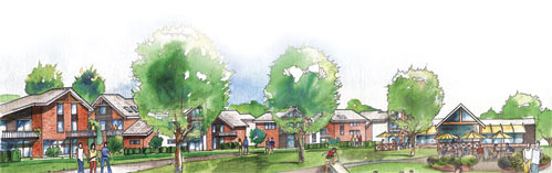
Building a new neighbourhood always brings change to the natural landscape that it replaces. A change that often goes unnoticed is what happens to the rainwater that falls on the neighbourhood — unnoticed, that is, until a road gets washed out.
The Change
A given plot of land in nature absorbs about 20 per cent of the rainwater in its top soil and gives off about 80 per cent of it through plant transpiration and evaporation. In most cases, 90 to 100 per cent of the water stays on-site, quenches the plants and recharges the aquifer.
Enter the new neighbourhood. Once completed, some 60 per cent of the rain will run off. The cause of this is straightforward: buildings and roads cover 30 to 40 per cent of the plot, and the plants of the covered portion go missing. Fewer plants to absorb water means more will flow out. Were it simply water that left the site, the outcomes would not be so worrisome. But runoff water carries with it a load of invisible, insidious contaminants.
Reduce Asphalt Impact
Ideally, a neighbourhood should produce no runoff, mimicking the original site, or only a tolerable five per cent of the rainfall. Not only can it be done, it has been done by pioneer developers (www.waterbucket.com).
The logic is simple and the techniques far from complicated: if roads and buildings reduce natural absorbing surfaces and vegetation, then reshape them to compensate for the reduction.
Asphalt tops the list. Reducing street length and width and eliminating back lanes is a good start.
Street patterns for an average subdivision can vary by up to 50 per cent in their use of land for streets, from about 36 per cent (or more) of the site area in Right-Of-Way down to 27 per cent. Cities do not specify the percentage of land to be dedicated to streets; it is entirely a matter of design, giving the developer latitude for innovation. Find and apply street patterns that optimize both land use and accessibility; the Fused Grid, for example.
Reduce the pavement width to the lowest permissible (8 m for two or 6.2 m for one-way in some cities) and ask for less by making most streets purely residential (see Alternative Development Standards by the Federation of Canadian Municipalities).
Displace streets with paths wherever possible. Only cars need 60-foot wide asphalted streets; people will enjoy a 15-foot, exclusive path. No resident takes pride or pays a premium for living on a wide, asphalted road.
As for lanes, they do little for nature, the residents or the city. They add asphalt, reduce the yard size, increase the house cost, increase city maintenance costs and create hiding spots for suspect activities.
Having lowered the amount of asphalt, reduce the runoff from the road itself using an upgraded version of the old, simple swale you find in rural roads. This system has been tried in a 32-acre site retrofit with convincing results: a 98 per cent reduction in runoff, a more pleasant environment and 50 per cent lower costs versus the conventional method (see pictures and evaluations at www.seattle.gov/util/naturalsystems).
Plant More Vegetation
Streets provide an opportunity to make up for the displaced vegetation. Plant them heavily with trees. People love such streets, and studies have shown they positively impact property values. They also transpire large amounts of water (a large oak tree can give off 151,000 liters per year).
Where the streets still produce runoff that must be piped away, there is yet another means to reduce it: the in-street infiltration trench.
To make up for the covered site area, place the required open space (usually, at least five per cent, but more is welcome) strategically. Design it to perform multiple functions such as recreation, path hub/connector and raingarden.
Don’t mince on the size of back yards; they normally make up to 50 per cent of the available absorbing surface of an average subdivision and are valued by home-owners, particularly when lots become smaller. If the yard must be reduced for good reasons, compensate for it with nearby open space.
Alongside these measures, all open space in the neighbourhood can be made more absorbing by adding layers of top soil. How thick will depend on how far all the combined measures have taken the development in reaching its zero outflow goal.
After all these measures and techniques, there may still be room for improvement. It is hard to tell without calculations. Luckily, the Water Balance Model does exactly that (see www.waterbalance.ca). In fact, adaptations should start by using this model and then proceeding in cycles of compounded improvements.
At the end of the day, these measures pay for themselves by lowering costs, increasing the revenue from property and delighting residents — and Mother Nature will be happy too.
Fanis Grammenos is a principal of Urban Pattern Associates and was a senior researcher at CMHC for 20 years. He can be reached by e-mail, and you can see his planning work at www.fusedgrid.ca


